FreeWalkers Kennedy50 driving directions
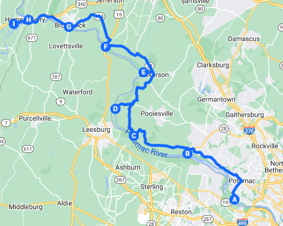
Master driving map
Select a mapChoose a map and driving directions basedupon your location and destination: |
C&O Canal access points
Access points between support stops are available for emergency assistance.| key | Abbrev | Access point | Milepost | Lat | Long |
|---|---|---|---|---|---|
| A | ANG | Old Angler's Inn | 12.2 | 38.981897 | -77.226205 |
| gre | Great Falls | 14.3 | 39.001748 | -77.246836 | |
| swa | Swains Lock | 16.6 | 39.031634 | -77.243531 | |
| pen | Pennyfield Lock | 19.6 | 39.054972 | -77.290334 | |
| vio | Violettes Lock | 22.1 | 39.067226 | -77.328483 | |
| B | RIL | Rileys Lock | 22.8 | 39.069167 | -77.340877 |
| syc | Sycamore Landing | 27.2 | 39.074731 | -77.420193 | |
| C | EDW | Edwards Ferry | 30.8 | 39.103463 | -77.472933 |
| D | WHI | Whites Ferry | 35.5 | 39.154861 | -77.518206 |
| dic | Dickerson Conservation Park | 39.6 | 39.194685 | -77.469402 | |
| E | MON | Monocacy Aqueduct | 42.1 | 39.222563 | -77.449987 |
| nol | Nolands Ferry | 44.6 | 39.249948 | -77.482726 | |
| F | POI | Point of Rocks | 48.2 | 39.273218 | -77.540045 |
| lan | Lander | 50.9 | 39.306507 | -77.558006 | |
| G | BRU | Brunswick | 55.0 | 39.311220 | -77.630749 |
| wev | Weverton | 58.0 | 39.329916 | -77.681966 | |
| H | HAR | Harpers Ferry | 61.2 | 39.32297 | -77.73069 |
| I | CLA | Clarion Hotel | 39.31627 | -77.76676 |
Driving directions
shaded areas=detour route for stop|
ANG Old Anglers Inn L on Macarthur Blvd 1.08 mi R on Falls Rd 1.96 mi L on MD-190/River Rd 8.10 mi L on River Rd 0.680 mi |
|
L on Rileys Lock Rd 0.700 mi RIL Rileys Lock Return on Rileys Lock Rd 0.700 mi L on River Rd 5.86 mi |
|
Continue on Mount Nebo Rd 1.60 mi Continue on W Offutt Rd 0.846 mi |
|
L on Edwards Ferry Rd 1.08 mi L to continue on Edwards Ferry Rd 676 ft EDW Edwards Ferry Return on on Edwards Ferry Rd 676 ft L on River Rd 1.38 mi |
|
R on Elmer School Rd 3.19 mi |
|
L on Whites Ferry Rd 2.42 mi WHI Whites Ferry L on Whites Ferry Rd 2.66 mi |
|
L on Martinsburg Rd 4.71 mi L on MD-28 W 1.50 mi |
|
L on Mouth of Monocacy Rd 1.22 mi Continue straight 673 ft MON Monocacy Aqueduct Return on Mouth of Monocacy Rd 673 ft Continue on Mouth of Monocacy Rd 1.22 mi L on MD-28 W 3.35 mi |
|
L to stay on MD-28 W 4.52 mi |
|
L on Monroe St 213 ft R on Commerce St 404 ft L on Canal Rd 305 ft POI Point of Rocks Head east toward Commerce St 272 ft Slight L on Canal Rd 407 ft R on Commerce St 404 ft L on Monroe St 213 ft L on MD-28 W 830 ft |
|
R on US-15 N 1.02 mi At circle, 3rd exit onto MD-464/Point of Rocks Rd 6.95 mi Continue straight onto 9th Ave 0.318 mi R on Park Ave 1,109 ft L to stay on Park Ave 1,040 ft R on E Potomac St 0.473 mi |
|
L on S Maple Ave 614 ft Turn right before woods 1,302 ft BRU Brunswick Return to town 1,302 ft L on S Maple Ave 614 ft |
|
L on Knoxville Rd/W Potomac St 2.32 mi L on MD-180 W 0.550 mi Merge on US-340 W 4.38 mi |
|
R on Shenandoah St 0.773 mi HAR Harpers Ferry SW on Shenandoah St 0.814 mi R on US-340 S/William L Wilson Fwy 1.23 mi |
|
L on Service Rd 157 ft CLA Clarion Hotel |